About School Performance Maps: Texas
School Performance Maps provides a "bird's eye view" of public school performance in Texas.
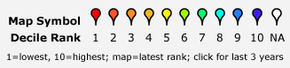
Performance Data
School performance data is from the Texas Education Agency, Academic Excellence Indicator System (AEIS). The performance decile categories represent the results of the school on standardized tests using the "standard accountability indicator" - percent of students meeting standards for all tests - compared to schools of the same type (e.g. elementary schools) across Texas. The marker icon is based on the results for the school for 2006-07. Info windows you see when clicking on each marker provide performance information for the last 3 years and links to more information for the school.
Geographic Data
Locations of most schools are from latitude and longitude information ("geocodes") from the National Center for Education Statistics Common Core of Data for public schools. Other school addresses were geocoded using Yahoo Maps Geocoding API. Accuracy of locations varies. Where multiple schools have the same address, some of the marker locations are adjusted slightly to reduce overlapping. You may need to zoom the map in to see markers that could be hidden behind others. Proximity of a residential address does not indicate inclusion in a school's attendance area; contact the local school district for attendance eligibility information.
Legal
The information displayed on this site and software incorporated in this site are provided for your use with no warranty of any kind. No personal information is collected on this site.
Contacting School Performance Maps
Feel free to contact us with questions, suggestions, corrections. If you are interested in advertising on this site, or consulting on custom mapping or other web development for your own site, please let us know.

Apologies for the lack of a mailto: link or copyable address -- we do not have time to deal with tons of spam! Thanks for visiting School Performance Maps.